数量有限
提早预订,获得最划算价格
最低价保障
无额外预定费用
冰岛旅拍婚纱照写真 |雷克雅未克出发|一日跟拍
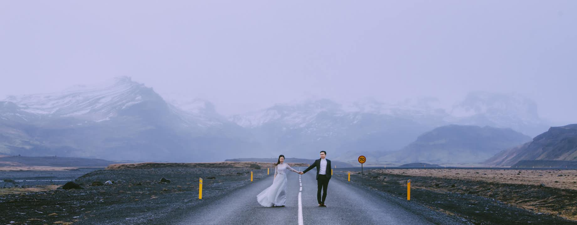
在冰岛旅游期间,拍一组梦幻纯美的婚纱照,私奔到世界尽头。冰岛本地摄影师跟拍,打造您的境外蜜月旅拍,极具个性化,文艺清新,与具备艺术感的冰岛大自然融为一体。极致的冰岛风景前,拥吻最爱的人。无论您是冰岛自由行还是自驾,您都将收获浪漫的欧洲纪念影集。
团队简介:
-我们是一支集创意、美学于一体的冰岛本土摄影团队,团队成员皆毕业于冰岛艺术院校,在冰岛用丰富的摄影经验和独特的艺术视角,基于对冰岛本土环境的熟悉和东西方美学相结合,来打造与众不同的婚纱摄影,表达爱与冰岛气氛的融合,创作出有诗意有故事的场景。
-摄影师Ywey毕业于冰岛艺术学院,在冰岛居住多年,喜欢从不同的视角探索和发现冰岛的魅力,游历过冰岛的每一寸角落的她,善于运用光和影的结合,将创意融入到自然的构成中,对冰岛拍摄有着独到的见解;在色彩方面也一直致力于挖掘契合冰岛的最佳色调。她也被Instagram推荐为人气摄影师。一对怀着炽热的心相恋的两个人在冰岛这个冰冷广袤,人烟稀少的土地上能够碰撞出什么火花呢?Ywey希望与新人一同来创作出不一样的婚纱摄影。
行程概述:
我们从首都雷克雅未克出发,或是徜徉冰岛南部的雄伟的瀑布、广袤的苔藓、凝结远古时代的玄武岩、黑色的魔鬼沙滩,澄澈干净的冰川,或是领略雷克亚内斯半岛的悬崖峭壁,绿宝石湖泊森林,也能够穿梭在雷克雅未克这个色彩缤纷的城市。又或是沿海湾去往雪山半岛,领略冰岛缩影,在奇石怪滩还有壮阔的悬崖。相信一路上波澜壮阔的景色,加上变幻莫测的天气,都给予我们全新的灵感,也能够带给您全新的体验。
我们设计了三条一日拍摄线路您可以随自己的喜好选择:
A-雷克亚内斯半岛
白雾茫茫的Krysuvik地热区;Kleifavatn清澄湖泊,途经Grænavatn绿宝石湖;到达Miðlína板块之桥。
B-冰岛南部海岸
塞里雅兰瀑布 + 斯科加瀑布 + Vik维克小镇教堂 + 玄武岩山洞 + Reynisfjara黑沙滩及周边
可以深入内部的水帘洞一般的塞里雅兰瀑布;水雾蒸腾的斯科加瀑布;经典的Vik山顶教堂;鬼斧神工天然排列的六棱柱玄武岩;黑的不可思议的魔鬼黑沙滩。
C-斯奈山半岛沿线
Buðir黑教堂 + 阿尔纳斯塔皮情人桥 + 海德纳尔悬崖礁石 + 斯奈山马场及沿线
在独具冰岛风格的布吉尔黑教堂许下誓言;在斯奈山冰川的见证下走过阿尔纳斯塔皮情人桥,惊涛拍浪的海德纳尔悬崖……
行程速览
- 运营日期 2月. - 12月.
- 长度 8 小时
- 难度 中等
- 语言 English, Chinese
- 亮点 雷克雅未克,
Reykjavik is the capital of Iceland and the northernmost capital of a sovereign state in the world.
Despite a small population (120.000 and more than 200.000 in the Greater Reykjavik area), it is a vibrant city that draws an ever increasing number of visitors. It is the financial, cultural and governmental center of Iceland. It also has a reputation of being one of the cleanest and safest cities in the world.
Geography
The city of Reykjavik is located in southwest Iceland by the creek of the same name. Throughout the ages, the landscape has been shaped by glaciers, earthquakes and volcanic eruptions and the area is geothermal. Much of the current city area area was subglacial during the Ice Age, with the glacier reaching as far as the Alftanes peninsula, while other areas lay under the sea. After the end of the ice age the land rose as the glaciers drifted away, and it began to take on its present form.
The coastline of Reykjavik is set with peninsulas, coves, straights and islands, most notably the island of Videy, and seabirds and whales frequent the shores. The mountain ring as seen from the shore is particularly beautiful. Mount Esja is the highest mountain in the vicinity of Reykjavik and lends its distinct feature to the whole area. This majestic mountain is also highly popular for climbing. Other notable mountains that can be seen from the seaside are Akrafjall and Skardsheidi and on clear days one may even see as far to the legendary Snaefellsjokull glacier, at the end of the Snafellsnes peninsula.
The largest river to run through the city is Ellidaa in Ellidaardalur valley, which is also one of Iceland‘s best rivers for salmon fishing.
Transportion
There are no trains or trams in Iceland, but most people travel by car. The city also operates a bus system. There are two major harbours in town, the old harbour in the center and Sundahofn in the east. The domestic Reykjavik Airport is located at Vatnsmyrin, not far from the city center and close to Oskjuhlid and Perlan. The international Keflavik Airport at Midnesheidi heath then lies around 50 km from the city. Cars, jeeps and bicycles can be readily rented in the city and many organized tours are also being offered.
What to See & Do in Reykjavik
The local arts scene is strong in Iceland, with both annual events and single ones, many of whom have hit the international stage. For the annual ones please check our articles Best Annual Events in Iceland and the Top Ten Festivals in Iceland. Major events taking place in Reykjavik include the Iceland Airwaves, Gay Pride, RIFF (The Reykjavik International Film Festival), The Reykjavik Literature Festival, Cultural Night, the Reykjavik Arts Festival, Food & Fun, the Reykjavik Fashion Festival and the Sónar music festival.
Among famous people from Reykjavik are artists Bjork Gudmundsdottir, Sigur Ros, writers Halldor Laxness (born in Laugarvegur) and Arnaldur Indridason and mayor Jon Gnarr. For more well-known and fairly-well known Icelanders, check our article on the subject.
You might also want to check our article on some of the many things to see and do in Reykjavik, such as visiting the city‘s many museums, exhibitions and galleries, checking out live music, visiting the Harpa music hall or the theaters, visiting the lighthouse at Grotta, the main shopping street of Laugavegur, visiting the old harbour and the flea market, going on a bird- and whalewatching tour or visiting Videy island. We also have a top ten list of things to do.
Make sure to visit the publis square of Austurvollur, one of the city‘s most popular gathering places, where you‘ll also find the national parliament, Althingi, the state church a statue of independence hero Jon Sigurdson, as well as cafés, bars and restaurants. Austurvollur was central in the 2008 protests, along with Laekjargata, home to the House of Government. You are also not likely to miss the great church of Hallgrimskirkja that towers over the city from the hill of Skolavorduholt, wherefrom you‘ll get a great view of the city.
Try a walk by the city pond, greet the many birds that frequent the area and visit the city hall, stationed by its banks. The Hljomaskalagardur is a beautiful park that lies by the pond, it ideal for a nice walk and sometimes concerts get held there. Further off is the campus of the university of Iceland, the Nordic house and the Vatnsmyri wetland, a particularly pleasant place, but be mindful of not disturbing the wildlife there and keep to the pathways.
For a nice swim on a warm day, we particularly recommend Nautholsvik beach.
Visit the Laugardalur valley, home to one of the city‘s best swimming pools, as well as the Asmundarsafn gallery, a beautiful botanical garden and a domestic zoo. A walk by the Aegissida beach, with it‘s old fishing sheds, in the west part of Reykjavik also holds a particular charm. The aforementioned Elllidaardalur valley is also a popular resort.
Another place that offers one of the city‘s best (and free) views is Perlan, up in Oskjuhlid hill. The hill itself is a popular resort, with over 176.000 trees and great opportunities for walking and cycling.
Travel to Alftanes to see the president‘s house at Bessastadir, which is also a historical site in it‘s own right, having been the educational center of Iceland for centuries. Nearby is a beautiful lava field, Galgahraun, well worth a visit, though there is currently an environmental struggle going on as to it‘s future state.
The city is furthermore a short drive from many of Iceland‘s major attractions, most famously the Golden Circle and the Blue Lagoon. In close vicinity you‘ll also find the Heidmork preservation area, a favorite passtime resort of the people of Reykjavik, as well as the Blue Mountains, one of Iceland‘s most beloved skiing venues.
Check our Best of Reykjavik guide further for tips on the best cheap things to do in Reykjavik, some of the best restaurants in the city, happy hours, the top ten value places to eat and our two articles on the famous Reykjavik nightlife; Nightlife in Reykjavik and Nightlife and mating.
Finally, we‘d like to stress that these are only some suggestions of the many things you might check out in Reykjavik. Whatever you choose to do, we hope you‘ll be able to make the most of your visit and we wish you a pleasant stay in our capital.
Heiðmörk,Heidmork is conservation area of over 300 hectars of land and a favorite pastime location, situated on the outskirts of Reykjavik.
Heidmork is one of he primary sources for cold water in the capital region. It also has a beautiful forest of over five million plants and about 150 species of flowers. Rabbits and over 60 types of birds can be found there. Of particular note are Raudholar, a spectacular remainder of a cluster of pseudocraters and the salmon river Ellidaar. A number of caves can be found in the area, such as Mariuhellir and Draugahellar. During World War Two the British army used material from the craters to build the airport in Reykjavik.
斯科加瀑布(森林瀑布),Skógafoss is one of the country’s biggest and most beautiful waterfalls with an astounding width of 25 meters (82 ft) and a drop of 60 meters (197 ft). Due to the amount of spray the cascade produces, a rainbow is present any time the sun emerges from behind the clouds.
Located on the Skógá river, this mighty cascade is clearly visible from Route 1 and is an excellent place to stop and stretch the legs while travelling Iceland’s South Coast. The river below Skógafoss holds a large char and salmon population and is thus a favourite spot for fishermen in the summer.
The land underneath the waterfall is very flat, allowing visitors to walk right up to the wall of water. Keep in mind, however, that this will get you drenched. Skógafoss can also be viewed from the top as a steep staircase leads to an observational platform above the cascade.
Geography
Skógafoss is located near the small village of Skógar, south of the Eyjafjallajökull glacier volcano. There you’ll find the Skógasafn folk museum, an open-air museum with both old wooden houses and turf houses, as well as a regional museum with various artefacts from this area.
A part of the Skógasafn Regional Museum is the Museum of Transportation, which showcases the history and evolution of transportation, communication and technologies in Iceland. There, you can see how this nation evolved from the age of the working horse to the digital communications of the 21st century.
The Skógasafn museum also includes a café and a museum shop, and in the village of Skógar, you will find both a hotel and a restaurant.
At the eastern side of Skógafoss, you will find one of Iceland’s most famed hiking routes; the Fimmvörðuháls pass. The 22 km (14 mi) trail takes you along Skógá river, between two glaciers, Mýrdalsjökull and Eyjafjallajökull, before ending in the beautiful Þórsmörk valley.
Folklore
A gold ring is on display at the Skógasafn museum. According to legend, the ring is from a chest that was owned by Þrasi Þórólfsson, one of the first Viking settlers in the area. Folklore states that before his death in 900 AD, Þrasi buried a chest filled with gold in a cave behind Skógafoss waterfall.
Many attempts were made to retrieve the chest after Þrasi’s death, and years later, locals managed to grasp a ring on the side of the chest. As they pulled, the ring broke off, and the treasure was lost forever. The ring was then given to the local church before it made its way to the museum.
塞里雅兰瀑布,塞里雅兰瀑布是冰岛南部最著名的一个瀑布,瀑布的水流相对比较苗条,但高度在冰岛名列前茅,高达63米。瀑布非常美丽,最特别之处在于一条通向瀑布水帘背面的小径,让人可以走道瀑布后面。
迪霍拉里,The 120 meter high promontory Dyrholaey is the southernmost part of the mainland, only a short drive south of the Ring Road. It offers a breathtaking view and features spectacular outcrops and rock formations.
A notable attraction is the massive arch that the sea has eroded from the heartland, giving the island its name (‘dyr’=door’). One daredevil pilot even flew through it!
Dyrholaey has an abundance of birdlife, the most common being puffins and eider ducks. You can also enjoy the black beach, where the waves can provide an impressive sight. As these can be very wild, we do however advise uttermost caution.
Krýsuvík,Krysuvik is a geothermal area in the Reykjanes peninsula in Southwest Iceland, situated in the middle of the fissure zone on the Mid-Atlantic Ridge.
At Krysuvik you may see all kinds of solfataras, fumaroles, hot springs and mud pots. The soil is colourful, giving of hues of green, red and bright yellow. We also recommend the crater lake Graenavatn, with its luminous green colour, Kleifarvatn, Reykjanes's largest lake and the birdcliff Krysuvikurberg, nesting place of around 77 thousand sea birds, including kittiwake, auk, fulmar and gull.
斯奈山半岛,Snaefellsnes is a large peninsula extending to the west from West Iceland ending with a national park, Snaefellsjokull National Park, where the glacier towers over the scenery, as can sometimes be seen from Reykjavik, lending its beauty to the area.
Snaefellsnes peninsula
The peninsula stretches over 100 km to the west as a mountain ridge that includes active volcanoes and is unique in the variety of mountains found.
A few small and beautiful villages are located on the south side and a few fishing villages are on the north side: Rif, Hellissandur, Olafsvik, Grundarfjordur and Stykkisholmur. The last one is highly popular for travelers, featuring a volcano museum and a ferry that takes you across the fascinating Breidafjordur bay to Brjanslaekur on the south border of the Westfjords.
Other museums you might want to check out are the Maritime Museum at Hellissandur, the regional museum Pakkhusid at Olafsvik, and, last but not least, the shark museum at Bjarnarhofn, indeed listed as the nr. 1 Snafellsnes attraction by Lonely Planet Travelers. Also, many of the Icelandic sagas take place at Snaefellsnes.
Snaefellsnes has an abundance of interesting sights. At the national park, you can witness the impressive lava formations of Djupalonssandur creek and test your strength on its four stones, see the two massive lava formations that compries Londrangar, explore the Saxholl volcanic crater and enjoy the echo of 'The Singing Cave', Songhellir. You may also hike on the majestic Snaefellsjokull glacier. The glacier has strong ties with folklore and was the setting for Jules Verne's Journey to the Center of the Earth.
Other sights we can recommend at Snaefellsnes recommend include Raudfeldsgja canyon, east of the national park and the rugged and colourful Berserkjahraun lava field, near Bjarnarhofn, on the north side of the peninsula.
Last, but not least, Snaefellsnes is one of the main setting for Laxdaela saga. Chieftain Snorri godi, Gudrun Osvifursdottir, Bolli Thorlakssson all lived there as well as his namesake Bolli Bollason, the first West Norse member of the Varangian guard, an elite unit of the Byzantine army. Iceland's most famous mass murderer, Axlar-Bjorn, also lived at Snaefellsnes.
Reynisfjara黑沙滩,Reynisfjara is a world-famous black-sand beach found on the South Coast of Iceland, just beside the small fishing village of Vík í Mýrdal.
With its enormous basalt stacks, roaring Atlantic waves and stunning panoramas, Reynisfjara is widely considered to be the most beautiful example of Iceland’s black sand beaches. In 1991, National Geographic voted Reynisfjara as one of the Top 10 non-tropical beaches to visit on the planet.
Reynisfjara is found around 180 km from Iceland’s capital city, Reykjavik, and is a popular stop-off for those taking a sightseeing tour along South Coast. Driving to the beach is particularly easy, taking an approximate two and a half hours from the capital.
Folklore
Upon visiting the beach, travellers will immediately observe rocky sea stacks sitting off the shoreline, known as Reynisdrangar. According to local Icelandic folklore, these large basalt columns were once trolls engaged in trying to pull ships from the ocean. However, as bad luck would have it, the dawn quickly arose, turning the trolls into solid stone.
Another legend tells of a husband whose wife was kidnapped and killed by two trolls. The man followed the trolls down to Reynisfjara where he froze them, ensuring that they would never kill again.
The sea stacks themselves are home to thousands of nesting seabirds. Species that can be found here include Puffins, Fulmars and Guillemots, making it a must-see location for all birdwatchers out there.
Potential Dangers
Visitors to Reynisfjara must be made well aware of the potential dangers present at the beach. First of all, the rolling, roaring waves of Reynisfjara are particularly violent, often pushing far further up the beach than many would expect.
Visitors are advised to never turn their back on the waves, don't go chasing after them and keep a safe distance of 20-30 metres.
Aside from these sudden and dramatic shifts in tide (known as “sneaker waves”), the currents off the shore are infamous for their strength and ability to drag helpless people out into the freezing cold open ocean. A number of fatal accidents have occurred at Reynisfjara, the last of which occurred in January 2017.
海勒那尔小镇,Hellnar is an old fishing village on the westernmost part of the Snaefellsnes peninsula. It used to be one of the largest fishing stations of the peninsula, the oldest record of seafaring there being from 1560.
At the shore are spectacular rock formations. Among them is a protruding cliff called Valasnos. Tunneling into the cliff is a cave renowned for its changing colourful hues, according to the light and sea movement. Large colonies of birds also nest in the area.
At Gvendarbrunnar a.k.a. Mariulind you can taste excellent spring water which is said to have healing powers.
Hellnar hosts the guesthouse for Snaefellsnes National Park and has a very interesting exhibition about the economy of former times and on the geology, flora and fauna of the national park.
阿尔纳斯塔皮,Arnarstapi is a village in the southern part of the Snaefellsnes peninsula. The area has several old and charming houses with interesting stories to them and is furthermore renowned for its beautiful nature.
The beach holds a particular attraction. It has an eroded circular stone arch, called Gatklettur, and three rifts, Hundagja,Midgja and Musagja. The interplay of spectacular waves and the light of the sun creates a fascinating spectacle. Large colonies of the arctic tern also nest in the area.
An old horse trail through the lava field Hellnahraun is highly popular for hiking, due to the impressiveness of the surrounding landscape.
哈尔格林姆斯大教堂,Hallgrímskirkja is a Lutheran church, located on top of hill Skólavörðuhæð in the centre of Reykjavík. At 74,5 metres tall, it is the largest church in Iceland, and its tower offers a spectacular panoramic view over the city.
History and design
The church was designed by one of Iceland’s most renowned architects, Guðjón Samúelsson, who is said to have sought inspiration for his expressionistic design from elements of the Icelandic nature. These include glaciers, mountains and trap rocks, such as the hexagonal basalt columns that surround the waterfall Svartifoss in Skaftafell National Park.
The church took 41 years to build, with construction starting in 1945 and finishing in 1986. The leaders of the Church of Iceland wanted a building that would tower over the Catholic church of Landakotskirkja, also designed by Samúelsson. The large pipe organ inside Hallgrímskirkja, consisting of over 5000 pipes, was built by German Johannes Klais of Bonn and its construction was completed in December 1992.
Outside the church stands its predecessor; a statue of Leifur Eiríksson by American sculptor Alexander Stirling Calder. The statue was a gift from the United States in 1930, on the millennial anniversary of Iceland’s first legislative body Alþingi, founded in Þingvellir in 930 AD. Leifur Eiríksson was a Norse explorer from Iceland who discovered the continent of North America in the year 1000, more than half a century before Christopher Columbus.
Culture
The church’s namesake is Icelandic priest Hallgrímur Pétursson, a 17th-century poet and author of The Passion Hymns (Passíusálmar). The hymns are a vital part of Icelandic religious tradition and a stable of local literature, having been reprinted over 75 times since their original publishing in 1666.
The tower of the church is each day visited by hundreds of spectators who seek to enjoy its sweeping view of the capital. The observation tower can be accessed via a lift. Hallgrímskirkja counts as the most iconic landmark of the city of Reykjavík and is visible throughout most of the capital. It serves as a focal meeting point for several cultural events, for example, an annual gathering for watching the fireworks on New Year’s Eve.
Seltjarnarnes,Seltjarnarnes is a township in the Reykjavik district. It has a population of about 4600 people and land-wise it is the smallest township in the country (2 km²). It is situated at the tip of the peninsula of the same name.
The area around Grotta island and Bakkatjorn pond on Seltjarnarnes, both of them natural reserves, is particularly beautiful and rich with birdlife. A charming old lighthouse is located on Grotta.
Culturewise the township features a Medical History Museum, an independent theater and a star observation society. Seltjarnarnes has also made a name for itself in sports, football team Grotta playing in Iceland's second level and their handball team playing the premier division.
维克镇,Vik in Myrdalur valley is the southernmost village on the Icelandic mainland, located around 180 km from the capital Reykjavik.
Vik is important as a service center for the inhabitants and visitors of the marvellous Reynisfjara beach.
Reynisfjara is widely considered one of the most beautiful beaches on earth (see for example Islands Magazine). This black pebble beach boasts an amazing cliff of regular basalt columns called Gardar, which resembles a rocky step pyramid and out in the sea are the spectaculary shaped basalt sea stacks Reynisdrangar. The area has rich birdlife, including puffins, fulmars and guillemots.
教会山(草帽山),Kirkjufell (“Church Mountain”) is a distinctly shaped mountain found on the north coast of Iceland’s Snæfellsnes Peninsula, only a short distance away from the town of Grundarfjörður.
Kirkjufell takes it’s name from its resemblance to a church steeple, sharpened at the top with long curved sides. From other angles, the mountain can resemble a witch’s hat or even a freshly scooped ice cream.
Photography at Kirkjufell
Peaking at 463 m, Kirkjufell holds the honour of being Iceland’s most photographed mountain. Throughout the centuries, Kirkjufell’s striking slopes have acted as a visual landmark for seafarers and travellers.
Walking distance from Kirkjufell, one can find the photogenic waterfall Kirkjufellsfoss (“Church Mountain Falls”), an excellent subject for photographers who can easily frame the mountain in the background. Despite its relatively diminutive height, Kirkjufellsfoss’ three-pronged falls make the waterfall particularly stunning, even for Iceland.
At the base of the mountain, visitors will also be able to find a lake; on calm and clear days, this lake reflects a perfect mirror image of Kirkjufell, only adding to the fantastic photo opportunities around this area. On top of that, the colours of Kirkjufell change with the passing seasons; the summer see it a lush green, full of life, whilst the winter months scar the mountain’s face with a mask of barren brown and white.
Fans of the HBO series Game of Thrones will recognise Kirkjufell as a shooting location from Season 7 of Game of Thrones. The mountain is showcased from the scenes ‘beyond the wall’ when Jon Snow, The Hound and Jorah Mormont, among others, brave the wilderness in hopes of catching an undead wight. Having seen it in a vision, The Hound acknowledges Kirkjufell as “[...] the mountain like an arrowhead.” Even the Games of Thrones producers can’t resist capturing the mountain on celluloid!
Hiking Kirkjufell
There is a fairly steep trail to the top of Kirkjufell, from where there are magnificent panoramas of the surrounding fields, coastlines and rivers. The mountain takes roughly an hour and a half to ascend, and one and a half hours back to the bottom.
Alongside this mountain-track is a steeper route to the peak which involves two points where one needs to rope-climb. This route should never be attempted in the winter, and never without a certified guide. Given the steep elevation, it is highly recommended that you bring a sturdy pair of hiking boots, snacks and water to the trail.
Getting to Kirkjufell
Kirkjufell is extremely close to Grundarfjörður, a small town on the Snæfellsnes Peninsula, approximately two hours drive from Iceland's capital city, Reykjavik. From Grundarfjörður, one travels ten minutes west down Route Snaefellsnesvegur 54 to the base of Kirkjufell. Visitors have plenty of parking space to choose from, all free of charge.
Búðir,Búðir is a small hamlet in the municipality of Snæfellsbær on the westernmost tip of the Snæfellsnes Peninsula.
The hamlet is located in the lava fields of Búðahraun in the region of Staðarsveit in west Iceland. Búðir consists of a church and a country hotel but is otherwise uninhabited.
History
Búðir was once a prosperous fishing village and one of Snæfellsnes' most active trading posts. Medieval sources describe Búðir as one of Iceland's major ports and archaeological evidence suggests portal activity dating back to the earliest settlement of Iceland.
In the beginning of the 19th Century, the trading post was abandoned but today, the area prospers economically because of tourism.
Surroundings
Búðir boasts the vast lava field Búðahraun that reaches east from the hamlet towards the sea by Faxaflói Bay, and west to the reef of Hraunlandarif. The lava's source can be traced to the 88-metre tall volcanic crater Búðaklettur which is located in the middle of the lava field. The crater has an opening on its south-west side, where one can enter the 382-metre long Búðahellir Cave.
Búðahraun is acclaimed for its rich flora, boasting approximately 130 different plant species. These include rare and protected species such as four leafed clovers. The eastern part of the lava field has been an official nature reservoir since 1977.
Búðir also consists of a field of tall, windswept grass, and a beach of fair-coloured sand dotted with jet black lava rocks. Hótel Búðir is a charming country hotel where visitors can enjoy the reclusiveness of the surrounding area.
- Find Snæfellsnes Tours here
Búðakirkja
All that remains of Búðir’s former community is the black wooden church Búðakirkja. A man named Bent Lauridtsen got a bishop’s permit in 1701 to build a church in the area. When it came to deciding the location, an old woman reportedly suggested making a man spin in circles until he became dazed and then have him shoot three arrows into the air. Where the third arrow landed, the church should be built.
A small turf chapel was built two years later, where it stood until it was dismissed by orders of the Danish King Christian VIII in 1819. Several residents fought for the reclamation of the church until in 1849 the priest’s council allowed for the construction of a new house of worship—as long as the residents of Búðir would fully finance the project and see to its maintenance.
A woman named Steinunn had meticulously cared for the artefacts from the old chapel, which resulted in the church still donning some of its original items, such a door latch engraved by Bent in 1703. Renovations were made in 1951, and again in the 1980s when it got slightly relocated and reconstructed according to its original Danish design.
Reynisdrangar石柱群,Reynisdrangar are rock formations situated near the shore of Reynisfjara beach by the coastal village Vík í Mýrdalur on the South Coast of Iceland.
The formations are large and impending sea cliffs, made up of the rock type basalt, that serve as a vital part of the area’s allure as they shoot dramatically out of the ocean under the looming cliffs of Mt. Reynisfjall.
- Visit Reynisfjara and Reynisdrangar on these South Coast Tours
Dangerous Waves
The village of Vík only houses around 300 permanent inhabitants, but on a daily basis, travellers scouting the South Coast make their way there to visit what has been voted as one of the most beautiful non-tropical beaches in the world. The beach of Reynisfjara, however, can be highly dangerous if proper caution is not taken. As is evident from how the waves of the Atlantic Ocean crash upon Reynisdrangar, the currents here are strong, and sneak waves can easily carry anyone that’s standing too close out to sea. The beach is not for wading, but for admiring, and especially the mighty surf bursting on the base of these rocky cliffs.
Folklore
There is an Icelandic folk tale that explains the origin of the pillars’ eerie appearance. According to legend, a couple of trolls were busy dragging a stranded three-masted ship to shore when the sunlight hit them and turned them into pillars of rock for all eternity. In fact, numerous rock formations in Iceland carry with them tales of trolls or elves, and one has only to look at them to fathom why.
Surroundings & Wildlife
An alternative view of the bewitching cliffs and their surrounding sea can be enjoyed by venturing up Mt. Reynisfjall, by a road to the west of the village. The mountain furthermore functions as a puffin colony every summer, from April to September, meaning guests can enjoy the view in good company. Other birds can be seen gliding around the cliffs such as Arctic terns, fulmars and seagulls.
- See also: Puffin Watching Tours
Djúpalónssandur黑沙滩,Djúpalónssandur is an arched-shaped bay of dark cliffs and black sand, located on the Snæfellsnes Peninsula in western Iceland.
History & Monuments
The location was once home to a prosperous fishing village, along with other abandoned hamlets and ports of the area such as Búðir and Hellnar, from back when the Snæfellsnes Peninsula functioned as one of the most active trading posts of the island.
- See a selection of exciting Snæfellsnes Tours
Fascinating remnants of this period are for instance found in the form of four ancient lifting stones that still occupy the beach. The stones range in weight from 23 kg (50 lbs) to 155 kg (342 lbs) and were used to test the strength of fishermen. Their names are Amlóði (useless), Hálfdrættingur (weakling), Hálfsterkur (half-strong) and Fullsterkur (full-strong).
In 1948, the English trawler Epine GY 7 from Grimsby shipwrecked on the shore, with fourteen dead and five survivors. The rusty iron remains of the vessel remain scattered on the beach, now protected as a monument to those who perished.
Environment & Surroundings
The Snæfellsnes Peninsula boasts countless natural wonders, where locals and travellers both flock on a daily basis to enjoy the unique landscape and stunning coastlines. Djúpalónssandur’s black pebble beach is particularly stunning amidst rocky coastal lava formations, including the elusive Gatklettur, a large lava rock with a hole in the middle through which you can directly spot the Snæfellsjökull Glacier Volcano.
Behind the rock are two freshwater lagoons called Djúpulón and Svörtulón, with the former serving as the namesake of the bay. Believed in olden times to be bottomless, the water bodies were later revealed to reach the depth of five metres. Lagoons such as these are held in high regard amongst the Icelandic people, and Svörtulón is thought to possess healing properties, especially after having been blessed by Bishop Guðmundur góði ('the good') in the late 1100s.
A natural monument of the area is Söngklettur, or “singing rock”, a large lava rock with a reddish hue that resembles an elfish church. Other rock formations of folklorish appeal rest close by, including the alleged trolls-turned-to-stone Kerling and Lóndrangur.
Warning
When visiting Djúpalónssandur, take heed that these are treacherous waters and the Atlantic Ocean’s powerful suction can easily carry you out to sea. This beach is not one for wading, but enjoying from a safe distance, especially if the weather is stormy.
The glistening pebbles that make up the beach known as Djúpalónsperlur, or “pearls of the deep lagoon”, are gorgeous to look at and might seem appealing to stone collectors, but they are protected by law and should not be removed from the area by visitors.
南岸The South Coast of Iceland is the country's most visited sightseeing route, along with the Golden Circle.
The famed South Coast shoreline stretches from the greater Reykjavík area and is dotted with natural wonders such as cascading waterfalls, volcanoes both active and dormant, black sand beaches and glacier lagoons.
Geography, Nature & Wildlife
Iceland is divided into eight geographical regions. Out of these, the Southern Region is the largest, as it spans over 24.000 square kilometres with its administrative centre in the municipality of Selfoss.
What is known as the South Coast embodies the shoreline of this particular region. The area consists of a lowland that is mostly composed of marshlands, bays and cultivated pastures that are met by a series of black beaches where the estuaries to the east and west of the district close off the coastal body.
Underneath the soil rests a vast lava field, known as Þjórsárhraun. Its edges reach several hundred metres offshore where the ocean waves crash upon them, thereby protecting the lowland from the invasion of the sea. This results in the South Coast being unusually lacking in the deep fjords that so distinctly characterise the rest of Iceland's shore line.
The region boasts vibrant bird life during all seasons. It is not only rich with both marshland birds and seabirds but also migrating birds such as the North Atlantic puffin. Some species stay throughout the harsh Icelandic winter, including the northern diver, the loom and various species of gulls and ducks.
Highlights of the South Coast
The South Coast offers an unprecedented array of natural wonders that draw thousands of visitors each day. When driving the route from Reykjavík City, the highlights in their correct order are:
- Seljalandsfoss Waterfall
- Vestmannaeyjar; The Westman Islands
- Eyjafjallajökull Glacier Volcano
- Skógafoss Waterfall
- Sólheimajökull Glacier
- Dyrhólaey Peninsula
- Reynisfjara Black Sand Beach
- Reynisdrangar Sea Stacks
- Coastal Village Vík í Mýrdal
- Skeiðarársandur Glacial Sand Plain
- Vatnajökull National Park
- Jökulsárlón Glacier Lagoon
These attractions count for but a fraction of what the South Coast has to offer. The vast sand plains of Sólheimasandur are home to a crashed DC-3 Plane Wreck, and close to Seljavellir by the Skógar Village there's Seljavallalaug, one of the oldest swimming pools in Iceland.
- Explore the many wonders of the area on these South Coast Tours
出发时间 : 灵活
Your hotel in Reykjavik
摄影师+摄影助理,专业中文团队
新娘礼服任选(由于尺寸要求严格恕不提供男士服装)
拍摄张数:400张原片拍摄,全部赠送
后期修片:30张超精修图片
化妆
住宿
食物
建议携带
保暖的长外套,防滑的鞋子
如有皮草大衣或斗篷也请发图片给我们看是否适合入镜。
女生自己喜欢的小配饰等。
小贴士
由于婚纱摄影属于特殊产品, 与普通旅行团不同, 以下内容为该产品的取消条款:
1. 当工作室因为控制之外的原因(生病,受伤甚至死亡等)不得不单方面取消预约时,将会退给客户所付的全部款项,并出于道义推荐其他同行给客户,此后产生的费用或其他问题不应与工作室有关。
2. 根据Guide To Iceland一日游摄影类产品取消政策,客户需提前7天以上邮件联系我们进行取消或者修改,可获得85%的退款。当客户在7天以内取消则没有退款。
3. 在取消预约之前双方可以协商改期,即在适应浮来工作室的时间安排的情况下安排新的预约。所有费用将挪到新的预约时间里,取消条款则根据原来的预约时间计算。若双方协商改期失败,则参照取消条款安排退款。
4. 当天气恶劣时,工作室需和客人双方达成新的共识,商量改期或改拍摄地点。摄影师有权根据当天当时的天气等自然情况决定改变拍摄路线。如果因为极端天气完全无法拍摄也无法改期的情况下退全额,如果在可以更改路线的情况下客人不愿意出发则不予退款。
5. 制定计划过程中的图片仅为风格参考,最终出片以拍摄当时的实际情况为准则。
4. 所有照片版权将属于摄影师本人,摄影师有权用于作品宣传,如需获得版权则请与摄影师本人协商
5. 注意:此套餐不包含接送和化妆服务,如需要此类服务请和客服进行沟通,我们可以根据客户需求来推荐另行预定。
-化妆造型:我们有熟练化亚洲脸孔的本地合作化妆师,收费根据妆发程度和时间分为35000克朗或60000克朗两个档次。 需提前和客服沟通预约。
-接送车:自驾游的客人直接约好在雷市汇合之后跟摄影师的车出发到目的地,请和我们的客服沟通集合地点。如需要包车接送请在附加项里选择,我们将派车去您的酒店接送。
-集合方式: 如果您是自驾方式,摄影团队可以自行驾车在约定地点碰面,所以我们将接送服务作为附加项。选择接送的话则我们的拍摄车会在雷克雅未克范围内的酒店接上您一起出发。